Methods
The FLUχPEC project is organized in four different Work Packages (WP). A brief summary of the main methodological issues covered for each of these WP follows.
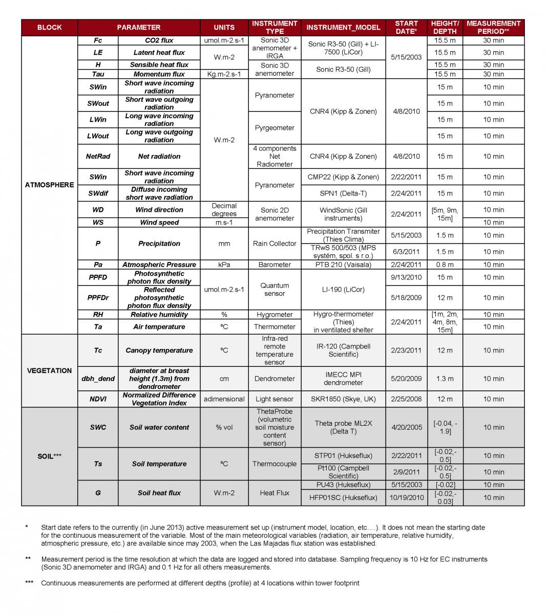
- WP1. Ground data collection: spectral measurements (optical, thermal, lidar), eddy covariance and biophysical variables: Ground data collection is a key issue in this project both to understand relations between biophysical parameters, fluxes and radiometric data and also to up-scale this information from the field to remote sensors.
- Optical information of the ecosystem components will be acquired using different approaches, ranging from handheld field spectroscopy campaigns (including sun induced fluorescence measurements) to continuous automated multi-angular acquisitions. These data will provide information about the physiological and biochemical status and productivity of vegetation.
- Multiangular temperature measurements of the different components of the ecosystem will be acquired using thermal sensors to estimate the energy fluxes.
- Terrestrial Lidar Scanner (TLS) will provide accurate information of the ecosystem structure, and its changes along the phenological stages.
- Biophysical variables of vegetation will be sampled. This data will be used for model calibration and validation.
- Continuous micrometeorological measurements will quantify the fluxes in the ecosystem.
- WP 2. Models to estimate carbon and water fluxes using spectral data: Physical (Radiative Transfer based) as well as empirical models will be calibrated and validated to estimate carbon an water fluxes from ground observations as a base for later remote estimations.
- Carbon fluxes will be modeled using different approaches including vegetation spectral indexes and light use efficiency models.
- Water fluxes will combine optical and thermal information with meteorological information using empirical and physical models.
- WP3. Upscaling ground observations using UAV, airborne and satellite imagery: Spectral information will be acquired from remote sensors at different spatial resolutions, allowing to understand the effects of ecosystem structure across the upscaling.
- High spatial-spectral resolution imagery will be acquired from UAVs and airborne sensors, allowing to separately observe the different elements of the ecosystem in intensive campaigns.
- Images with coarser spatial resolution but higher temporal resolution will be acquired from remote platforms providing information in the optical, thermal and also RADAR domains.
- WP 4. Monitoring and analyzing the dynamics of change in water and carbon fluxes through proximal and remote sensing: Information generated in previous WPs will allow analyzing the fluxes dynamics and its estimates at different temporal scales
- Daily: Using the continuous optical, thermal and micrometeorological systems, and high temporal resolution imagery.
- Seasonally: Using periodical field campaigns and imagery acquired at different scales.
- Historically: Using EC and satellite imagery time series.


