Structure
The capability to process spatial information across scales (local, regional and global) has been advocated as a solution to better understand the global system for both natural (e.g. global climate change) and societal (e.g. global economy) processes and the relationships between both. However, scaling represents a scientific challenge because of the non-linear nature between processes and variables, and the heterogeneity of characteristics determining the rates of processes. This project propose a multi-source approach to combine remote sensing products of various spectral and spatial scales (field spectroscopy, airborne and satellite images) with flux measurements in order to analyze and quantify more robustly the water and carbon balance at ecosystem level. Empirical and physical based models will be used to estimate fluxes at ground level that will be upscaled using spectral data acquired from unmanned aerial vehicles (UAV), airborne and satellite. The dataset underlying the study will consists of various spaceborne (Landsat, MODIS and SEVIRI) and airborne (AHS, CASI and hyperspectral sensors onboard UAV) reflectance datasets at different spatial and spectral resolutions. Ground information will be acquired continuously in the same area using unattended multiangular hyperspectral sensors. Field data will include spectral measurements as well as measurements of biophysical vegetation parameters, meteorological variables and CO2, H2O and energy fluxes at ecosystem scale. This information will be necessary for either calibration and/or validation purposes. The following flowchart outlines the proposed approach.
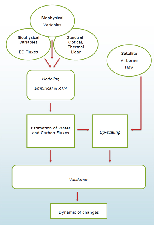 |
The FLUχPEC project will be organized in four different Work Packages (WP). The logical sequence will start with data generation activities (WP1) which will include field measurements of biophysical variables, field spectroscopy, eddy covariance flux measurements and airborne/satellite image acquisition. Secondly, multi-scale spatial estimations of carbon and water fluxes will be generated using empirical models and RTMs (WP 2 and 3). Thirdly the capacity of proximal and remote sensing to track the dynamics of EC fluxes at different temporal scales: daily, seasonally and inter-annually will be analyzed (WP4).